Benthic Habitat Viewer
The online Benthic Habitat Viewer (BHV) database, developed and managed by the National Centers for Coastal Ocean Science (NCCOS), provides easy access to a large database of underwater imagery characterizing coral reef organisms and habitats. The database holds over 9000 underwater seafloor images, taken during mapping missions from 2004-2006 in Puerto Rico and the U.S. Virgin Islands. These data were collected to support comprehensive seafloor characterization of the U.S. Caribbean. Funded by NOAA’s Coral Reef Conservation Program, the online database facilitates a variety of coral reef mapping, research, management and educational opportunities. The underwater imagery is accompanied by information on image location, biological inventory, benthic habitat characterization, geomorphological structure, and seafloor terrain characteristics (i.e., bathymetry, slope, and rugosity). The database will continue to be updated with additional imagery as data is collected from future missions.
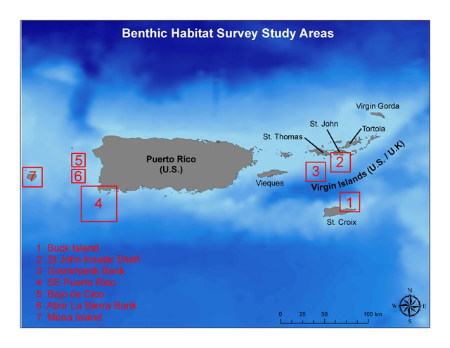
Select a region from the map or below to explore.
Helpful Links
Directions
The imagery database and this website are organized in a hierarchical manner by geographic location.
1. First, images are organized by broad-scale geographic region,
2. then by cluster (e.g., transect, drop camera site)
3. and finally by point.
To navigate the website select a geographic region by clicking one of the red boxes on the map. You will be taken to that regional page with a map and a list of clusters. Bathymetric data underlies each cluster to provide basic information on geographic zoning.
Once a cluster is selected, an image within the cluster will appear with corresponding data on location, benthic habitat type, geomorphological structure, and seafloor terrain characteristics (i.e., bathymetry, slope, and rugosity). In addition, a map showing the location of the image in reference to fine-scale bathymetric data and a depth profile showing the location of each image to overall bathymetry are provided on the two bottom panes. Users may navigate among all images within a cluster by clicking on the forward or reverse arrow keys. Double arrow keys jump by five images allowing faster navigation. To navigate to another cluster simply click “Back” on the web browser
Benthic Habitat Classification Scheme
Geomorphological Structure Type
1. Unconsolidated Sediment
1. Sand
2. Mud
2. Coral Reef and Hardbottom
1. Linear Reef
2. Spur and Groove
3. Patch Reef
4. Scattered Coral/Rock in Sand
5. Scattered Coral/Rock in Mud
6. Reef Rubble
7. Pavement
8. Pavement with Sand Channels
9. Bedrock
10. Bedrock with Mud Accretion
11. Bedrock Ledge
3. Other
1. Consolidated/Semi-consolidated Mud
2. Algal Nodules
3. Channel, Rill, Gully in Mud
4. Unknown
Biological Cover Type
1. Live hard coral (Stony Corals, Hydrocorals)
2. Live soft coral (Gorgonians, Black Coral)
3. Sponge
4. Seagrass
5. Macroalgae
6. Coralline algae
7. Turf/Filamentous algae
8. Sessile cnidarians, segmented worms and crinoids
9. Uncolonized
10. Unknown