About the Project
 The Ecological Assessment of Storm Impacts on Marine Resources is a part of the Coastal Storms Program (CSP), which is a nationwide effort led by the National Oceanic and Atmospheric Administration (NOAA) to lessen the impacts to coastal communities from storms.
Project Description
The Ecological Assessment of Storm Impacts on Marine Resources is designed to assess potential effects on fish and shellfish from non-point source pollution. Pesticides used on farms, lawns and golf courses, petroleum hydrocarbons found in roadway runoff, and other contaminants in storm water runoff can cause illness or death to fish and shellfish.
Currently, the project provides information that can be used in preliminary land use-based risk assessments for pesticides potentially used in the St. Johns River watershed, and for a broad suite of contaminant types in the lower Columbia River watershed of Oregon and Washington states, U.S.A.
As part of NOAA's Coastal Storms Program, the National Ocean Service (NOS), National Marine Fisheries Service (NMFS), and the Office of Response and Restoration (ORR) are conducting research on the transport of contaminants, estimation of the risks to aquatic organisms, and mitigation approaches to reduce those risks. The project provides users with ecological assessment tools to identify areas of risks, and to mitigate impacts from coastal storms.
Geographic Locations
There are currently two geographic areas being studied.
- The Florida Pilot
- The Pacific-Northwest Pilot
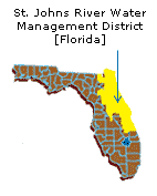
The Florida Pilot
The Florida pilot region is located along the northeast coast of Florida within the St. Johns River watershed. If you are interested in learning more about the St. Johns River Water Management District (SJRWMD), please visit their official website at www.sjrwmd.org. This region includes all or a portion of the following counties:
- Alachua
- Baker
- Brevard
- Clay
|
- Duval
- Flagler
- Indian River
- Lake
|
- Marion
- Nassau
- Orange
- Osceola
|
- Putnam
- Seminole
- St. Johns
- Volusia
|
The Pacific-Northwest Pilot
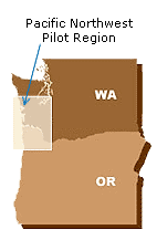
The second pilot program is in the U.S. Pacific Northwest. This pilot region focused on part of the Lower Columbia River, the northwest Oregon coast, and the southwest Washington coast.
Chemical contaminants, in additions to pesticides include many polycyclic aromatic hydrocarbons (PAHs) and inorganics. This region includes all or a portion of the following counties:
Washington
- Clark
- Cowlitz
- Grays Harbor
- Lewis
- Mason
- Pacific
- Pierce
- Thurston
- Wahkiakum
|
Oregon
- Clackamas
- Clatsop
- Columbia
- Marion
- Multnomah
- Tillamook
- Washington
- Yamhill
|
Project Status
A land use-based preliminary risk assessment was conducted to identify potential effects from toxic contaminants. Data on 516 chemicals that are expected to occur in either the St. Johns RIver or lower Columbia River watershed are provided. More than 170 pesticides are approved for use in agricultural, residential, and commercial applications within the St. Johns River watershed.
The database provides information on potential loadings and locations, known toxicology, and chemical characteristics that affect transport, fate, and toxicity. This database of information is available for query through our basic search and our detailed search.
Data Research and Collection
Several steps were taken to compile the list of contaminants to be included in each pilot area risk assessment and this database. For the Florida’s SJRWMD and the Pacific Northwest pilot areas, we used the Pesticide Product Information System (PPIS) from the Environmental Protection Agency's (EPA) Office of Pesticide Programs (OPP). From the files in this system, we were able to obtain a list of pesticides registered for use on the landcovers found in our pilot areas. The landcovers for each pilot area were based upon the most recent and most detailed landcover data available to us.
The agricultural pesticides for SJWMD were derived from Florida’s Department of Agriculture and Consumer Services: Bureau of Pesticides provided the “Summary of Agriculture Pesticide Usage in Florida: 1995-1998.” This document lists pesticide application rates according to crop and county for the state of Florida. A document such as this was not available for the Pacific Northwest pilot area, so the agricultural pesticides were determined using the PPIS system described above.
For the Pacific Northwest pilot, our risk assessment also included polycyclic aromatic hydrocarbons and inorganic contaminants that were selected for inclusion based upon available scientific literature suggesting the potential for risk to aquatic resources. A panel of scientific experts was convened to review and revise the list of contaminants.
If you would like to learn more about the development of the project database, view the database development process.
Please view our contact information, if you would like to learn more about the Ecological Assessment project.
FGDC Metadata
The Federal Geographic Data Committee (FGDC) is an interagency committee that promotes the coordinated development, use, sharing, and dissemination of geospatial data on a national basis. View this project's metadata file (XML format).